Where Is the Geologic Hazards Information? - Ivan D. Djambov Last Updated: September 22, 2014
The landslide of August 5, 2014 in North Salt Lake left one
home destroyed and neighbors worried about their own homes, with one of them
quoted in the media wondering "Did we build in the right place?" How can home buyers and local government
officials know if an area is safe in terms of geologic hazards?
The home construction process includes permitting
and inspections, but generally, the home owners are not provided with information on geological hazards in the area. And also, damages or destruction to their
property due to geologic hazards are not covered in the regular homeowners
insurance.
Many
local government officials are also left in "the dark" as they respond to
requests for rezoning to accommodate proposed new development in their
boundaries without the needed geological hazard data. The lack of this information
often leads local governments to permit areas that are not suitable for
development. The results include excessive
maintenance costs and potential liability from damaged streets, sidewalks, and
utility infrastructure (water, sewer, and stormwater), along with increased
expenses for private electric, gas, and communications utilities. These
costs are ultimately borne by the taxpayer and utility subscribers. An example
of this is SunCrest development in the Draper area.
Is there any geologic hazards information available for
Utah? The answer is yes, for some areas. The Geologic Hazards
Program (http://geology.utah.gov/ghp/),
which is part of the Utah Geological Survey (UGS), provides geologic hazard map
sets for urban and rapidly-developing areas (see page 1 of http://geology.utah.gov/surveynotes/archives/snt41-3.pdf).
UGS staff prepares 10 or more maps for each area, including
the following types of hazards:
-
Seismic hazards (surface fault rupture and
liquefaction),
- Landslides,
- Rockfall,
- Flooding and debris flows,
- Problem soil and rock (collapsible soil, expansive
soil and rock, and radon), Shallow bedrock, and
- Shallow groundwater.
Analysis to develop the maps uses a variety of information, such
as:
- UGS
geologic maps (http://geology.utah.gov/maps/geomap/interactive/index.htm),
- Natural
Resources Conservation Service soil survey data,
- Federal
Emergency Management Agency flood mapping,
- UGS
collection of aerial photography (http://geology.utah.gov/online/aerial_photos/index.htm),
- UGS
collection of consultant geotechnical and geologic hazard reports (http://geodata.geology.utah.gov,
many provided by local governments),
- High-resolution
LiDAR data collected by the UGS and other partners (http://geology.utah.gov/databases/lidar/lidar.htm),
- Field
reconnaissance and mapping, and
- Other
data, as available
For more information on geologic hazards in Utah, please visit
http://geology.utah.gov/ghp/consultants/index.htm.
The Geologic Hazards Program has had two engineering geologists positions since 2009, tasked with the developing of these comprehensive geologic hazard map
sets. Due to the time and data
intensive, and highly technical nature of preparing these maps, publication is
somewhat slow. So far, the program has completed two sets for part of
western Salt Lake Valley (see the Magna and Copperton quadrangles at http://geology.utah.gov/online/ss/ss-137/ss-137.pdf
and http://geology.utah.gov/online/ss/ss-152.pdf)
with ongoing mapping in southern Salt Lake Valley and Utah Valley.
Mapping priorities are based on growth and development
projections. In the next five years, UGS
plans to map the following areas:
- Lehi and Northern Utah County,
- Saratoga Springs,
- Eagle Mountain,
- Cedar Valley, and
- Northern Salt Lake Valley
(including the City of North Salt Lake).
Geologic hazard maps and other
related information are not intended to prevent development. The purpose is to facilitate sustainable
development, and to limit future disasters with life, safety, and economic
damages to landowners and local governments. This kind of information is
intended to help home buyers and others make educated decisions before they
make their investments.
The key is to provide geologic hazard information
for all areas in Utah, to make it easy to understand and
use, and to put it in the hands of the public as soon as possible.
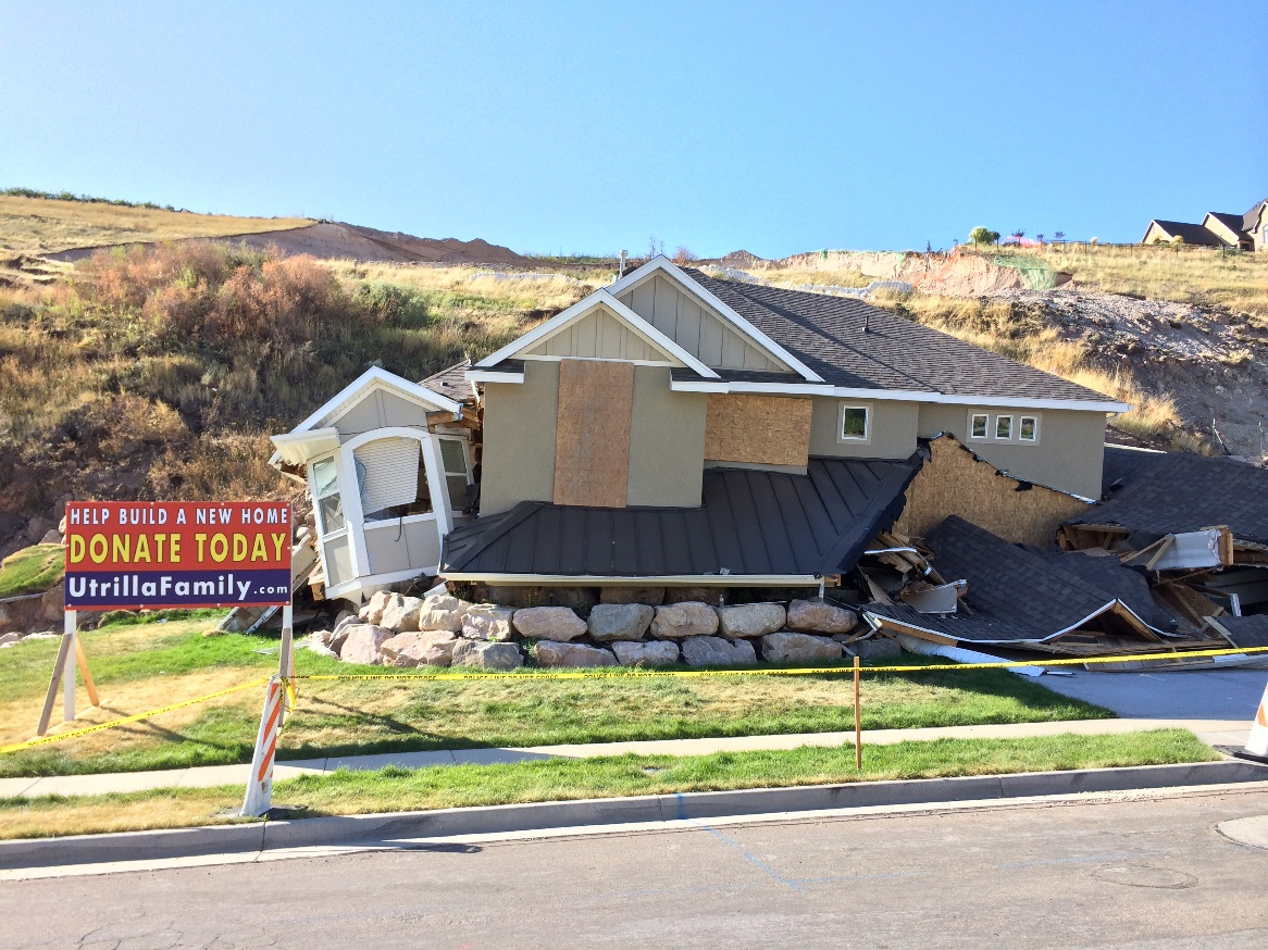
The landslide of August 5, 2014 in North Salt Lake left one home destroyed and neighbors worried about their own homes, with one of them quoted in the media wondering "Did we build in the right place?" How can home buyers and local government officials know if an area is safe in terms of geologic hazards?
The home construction process includes permitting and inspections, but generally, the home owners are not provided with information on geological hazards in the area. And also, damages or destruction to their property due to geologic hazards are not covered in the regular homeowners insurance.
Many local government officials are also left in "the dark" as they respond to requests for rezoning to accommodate proposed new development in their boundaries without the needed geological hazard data. The lack of this information often leads local governments to permit areas that are not suitable for development. The results include excessive maintenance costs and potential liability from damaged streets, sidewalks, and utility infrastructure (water, sewer, and stormwater), along with increased expenses for private electric, gas, and communications utilities. These costs are ultimately borne by the taxpayer and utility subscribers. An example of this is SunCrest development in the Draper area.
Is there any geologic hazards information available for Utah? The answer is yes, for some areas. The Geologic Hazards Program (http://geology.utah.gov/ghp/), which is part of the Utah Geological Survey (UGS), provides geologic hazard map sets for urban and rapidly-developing areas (see page 1 of http://geology.utah.gov/surveynotes/archives/snt41-3.pdf).
UGS staff prepares 10 or more maps for each area, including the following types of hazards:
- Seismic hazards (surface fault rupture and liquefaction),
- Landslides,
- Rockfall,
- Flooding and debris flows,
- Problem soil and rock (collapsible soil, expansive soil and rock, and radon), Shallow bedrock, and
- Shallow groundwater.
Analysis to develop the maps uses a variety of information, such as:
- UGS geologic maps (http://geology.utah.gov/maps/geomap/interactive/index.htm),
- Natural Resources Conservation Service soil survey data,
- Federal Emergency Management Agency flood mapping,
- UGS collection of aerial photography (http://geology.utah.gov/online/aerial_photos/index.htm),
- UGS collection of consultant geotechnical and geologic hazard reports (http://geodata.geology.utah.gov, many provided by local governments),
- High-resolution LiDAR data collected by the UGS and other partners (http://geology.utah.gov/databases/lidar/lidar.htm),
- Field reconnaissance and mapping, and
- Other data, as available
For more information on geologic hazards in Utah, please visit http://geology.utah.gov/ghp/consultants/index.htm.
The Geologic Hazards Program has had two engineering geologists positions since 2009, tasked with the developing of these comprehensive geologic hazard map sets. Due to the time and data intensive, and highly technical nature of preparing these maps, publication is somewhat slow. So far, the program has completed two sets for part of western Salt Lake Valley (see the Magna and Copperton quadrangles at http://geology.utah.gov/online/ss/ss-137/ss-137.pdf and http://geology.utah.gov/online/ss/ss-152.pdf) with ongoing mapping in southern Salt Lake Valley and Utah Valley.
Mapping priorities are based on growth and development projections. In the next five years, UGS plans to map the following areas:
- Lehi and Northern Utah County,
- Saratoga Springs,
- Eagle Mountain,
- Cedar Valley, and
- Northern Salt Lake Valley (including the City of North Salt Lake).
Geologic hazard maps and other related information are not intended to prevent development. The purpose is to facilitate sustainable development, and to limit future disasters with life, safety, and economic damages to landowners and local governments. This kind of information is intended to help home buyers and others make educated decisions before they make their investments.
The key is to provide geologic hazard information for all areas in Utah, to make it easy to understand and use, and to put it in the hands of the public as soon as possible.