Mission: The Utah Geological Survey (UGS) provides timely, scientific information about Utah's geologic environment, resources, and hazards.
UGS is organized in two areas: Support and Technical programs. The two support programs for the five technical programs are Technical Assistance and Administration. The Technical programs include:
- Geological Hazards
- Mapping Geology
- Energy and Mineral Resources
- Ground Water & Paleontology
- Geologic Information and Outreach
The Survey does not have regulatory power except in areas concerning paleontology. Otherwise, the agency must "assist," "advise," and "cooperate with" other groups.
During the 2015 General Session, the Legislature appropriated for Fiscal Year 2016, $8,483,100 from all sources for Utah Geological Survey. This is a 2.4 percent reduction from Fiscal Year 2015 revised estimated amounts from all sources. The total includes $3,071,800 from the General/Education Funds, a reduction of 0.5 percent from revised Fiscal Year 2015 estimates.
In addition to statewide compensation and internal service fund cost increases, the following appropriation adjustments were made during the 2015 General Session:
Due to the anticipated reduction in revenues from the Land Exchange Distribution Account, the division has recommended reduction to the appropriation from this funding source, in order to better match the available funding.
The following are the top measures chosen by division management to gauge the success of its programs.
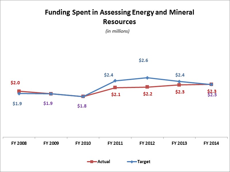
Funding Spent in Assessing Energy and Mineral Resources
Spending on Assessing Energy and Mineral Resources: The third measure tracks the division expenditures while identifying, inventorying, assessing, and encouraging the prudent development of Utah's minerals and energy.
Geologic Hazard Publications and Responses to Emergencies
Geologic Hazards Program: The second measure keeps track of the geologic hazard publications and the geologic hazard emergencies (such as earthquakes, landslides, debris flows, rock falls, and unstable ground) division staff has responded to over time.
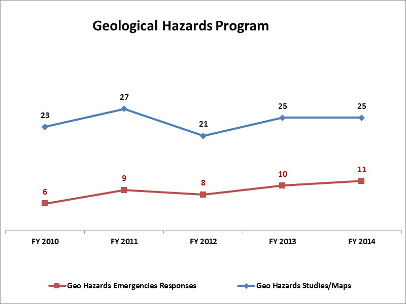
Division management hopes that the number of geologic emergencies will be low, which would mean that Utah had few hazardous events. However, these events are driven more by nature than by division personnel.
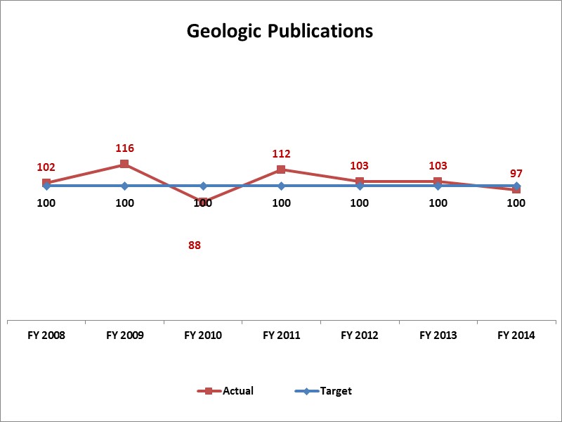
Number of Geologic Publications
Publications: Statute requires the Utah Geological Survey to prepare, publish and distribute maps and reports of the geology of the state. This measure keeps track of UGS' publications, which include geologic maps, books, and reports.
The following laws govern operation of the division:
- UCA 79-3-301 creates the Board of Utah Geological Survey. It consists of seven members with various backgrounds. The director of the School and Institutional Trust Lands Administration sits as an ex officio member.
- UCA 79-3-205 allows survey employees to trespass on any lands while on official business.
- UCA 79-3-502 prohibits anyone from excavating for critical paleontological resources on state/locally controlled land without first getting a permit from the survey.
- UCA 79-3-402 creates a special revenue fund known as the "Utah Geological Survey Sample Library Fund" consisting of donations and interest. The director administers the fund. The division may only spend up to the amount of interest generated in the previous fiscal year.
Statute (UCA 59-21-1, 2) allocates 2.25% of the state's share of federal mineral lease royalties to the survey. These receipts are a crucial part of the division's revenue, and in recent years have ranged between 20% and 40% of the total budget, depending on current energy prices. Typically, mineral lease revenues follow a combination of natural gas and oil prices with a two-month lag, but are difficult to predict due to variable production reporting systems.
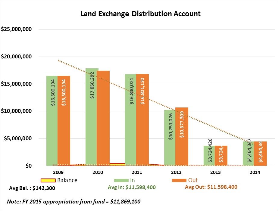
Statute (UCA 53C-3-203) also allocates 1.66% of all distributions made to the Land Exchange Distribution Account (established through H.B. 134 by the 2007 Legislature) to be made to the Utah Geological Survey, to be used for natural resources development in the state. Prior to that legislation, this funding was allocated to the Utah Geological Survey as part of its federal Mineral Lease royalties. Beginning with FY 2010, 1% of the deposits remaining in the account (after the appropriation is made in accordance with Subsection (4)(a) to UGS) is to be used for test wells, other hydrological studies, and air quality monitoring in the West Desert.
Special Funds
The figure below shows the activities of the fund over time, the appropriated amount for the current fiscal year, as well as the average revenues, expenditures, and balances.
COBI contains unaudited data as presented to the Legislature by state agencies at the time of publication. For audited financial data see the State of Utah's Comprehensive Annual Financial Reports.